 Kotor City Guide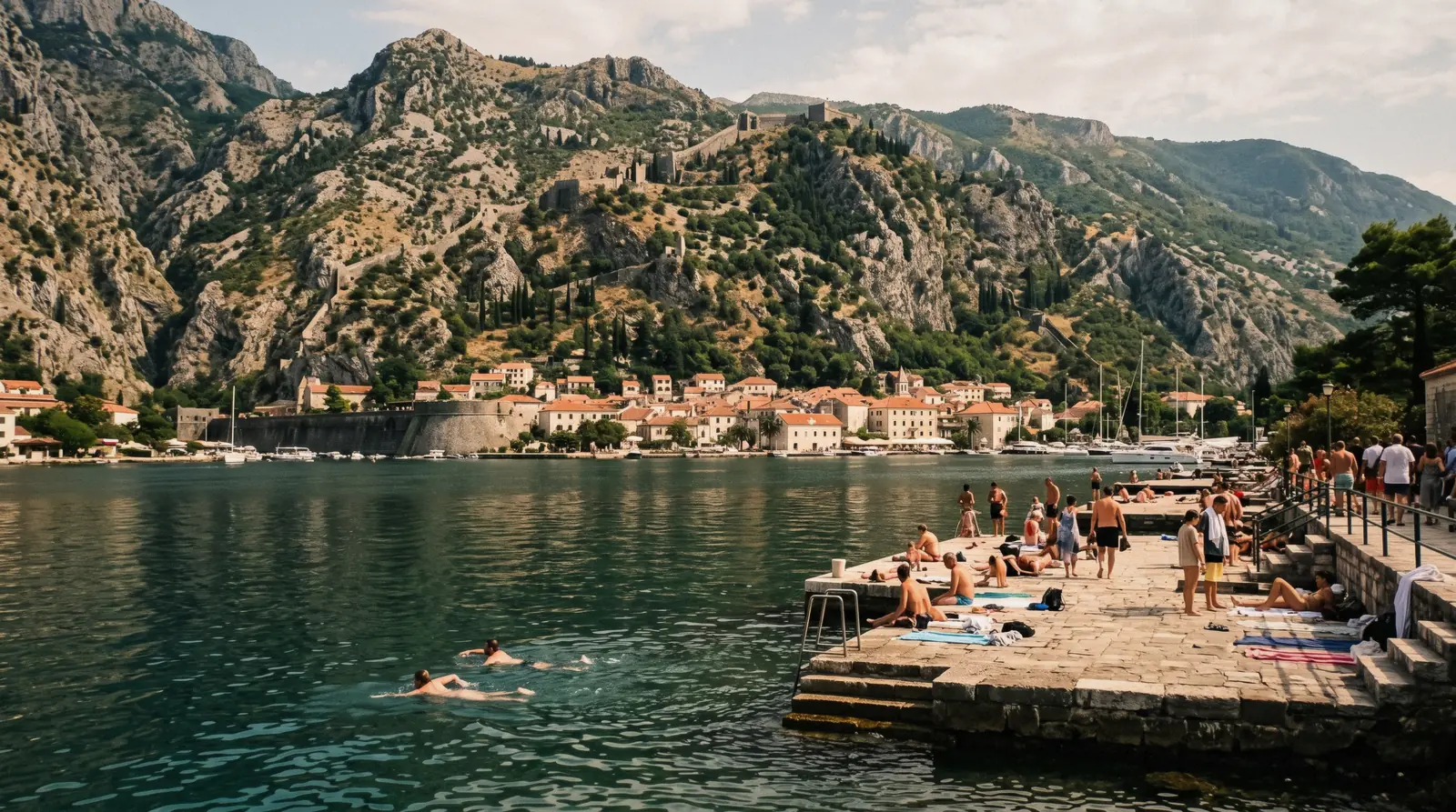
Kotor Beaches: Where You Actually Swim in the Bay
Kotor sits at the end of a fjord-like bay, and the first thing every swimmer notices is that the town has no sand. That is not a rumour and not a seasonal closure. Kotor town itself has no sandy beach at all. Swimming in town means stepping off stone slabs and old quays along the Kotor and Dobrota waterfront, straight into water that is calm, deep and clear. If you want sand under your towel, the beaches people actually mean when they search for Kotor beaches sit outside town: Trsteno and Plavi Horizonti on the Tivat side of the bay, and Jaz on the coast road toward Budva. This page sorts out which kind of swim you want, what each spot is like, how you get there, and what it costs, which in most cases is nothing. For the wider frame, start with the Bay of Kotor and things to do in Kotor. The full guide lives on Kotor City Guide.
Quick answer The answer first, then the details that decide it
You swim in two ways here. In town, you swim off the stone slabs and quays of the Kotor and Dobrota waterfront. Entry is a step or a ladder into deep, calm, clear water, and it is free. Out of town, you drive or ride to real beaches: Trsteno and Plavi Horizonti on the Tivat side of the bay and Jaz on the road toward Budva. There is no shallow sandy entry anywhere inside Kotor town itself, and that single fact shapes every decision on this page. If you have an hour free between sights, swim from the slabs. If you have a half-day, go for sand.
Key takeaways
- The full guide lives on Kotor City Guide.
- Kotor cruise port: the page that owns this question is at Kotor cruise port.
- Kotor with kids: the page that owns this question is at Kotor with kids.
- Start on the water: Boka Bay full-day cruise is the card most first-timers book.
Swimming Spots Compared
The table below lines up the main places people swim in and around Kotor. Distances and drive times for the out-of-town beaches are not published in the sources this guide checks, so the how-far column describes the route rather than a number. Entry means how you get into the water, which matters more than anything else here.
| Spot | Water | Entry | How far |
|---|---|---|---|
| Kotor town waterfront slabs | Calm, deep, clear | Stone slabs and quays, no shallow entry | In town, walk from the old town |
| Dobrota quays | Calm, deep, clear | Quays and ladders, no shallow entry | North along the waterfront from the old town |
| Kotor town beach | Calm bay water | Small town beach strip | A short walk from the old town along the shore |
| Trsteno | Open bay side, sandy bottom | Sandy beach entry | Across the bay on the Tivat side, not stated |
| Plavi Horizonti | Sheltered cove, sandy bottom | Sandy beach entry | On the Tivat side, not stated |
| Jaz | Open Adriatic | Sandy beach entry | On the road toward Budva, not stated |
Figures current in Q3 2026.
The Swimming Spots One by One
Every spot below is a real, used swimming place. What varies is the ground under your feet, the walk, and the trip to reach it.
Kotor town
-
Kotor Town Waterfront Slabs
stone slabs
These are the slabs most visitors mean when they ask about swimming in Kotor. Stone platforms run along the water's edge below the road that circles the town, and locals and visitors spread towels directly on the stone. The water here is calm because the bay at this end is sheltered on all sides, it is deep close in, and it is clear enough to see the stones below. There is no shallow entry, so you step or lower yourself off the edge. This is the swim you do when you have two free hours between the walls climb and dinner. Bring water shoes if you have sensitive feet, because the stone heats up through the day.
Tip: Free, no booking, a few minutes on foot from anywhere in the old town
-
Kotor Town Beach
small town beach
Kotor does have a small town beach, a narrow strip rather than a broad sandy bay, and it is the closest thing the town itself offers to a conventional beach afternoon. The water is the same calm bay water as the slabs, and kayaks rent here by the hour, which makes it the natural launch point for a self-guided paddle inside the bay. Families with small children should still note the town's basic reality: the classic Kotor waterfront entry is off stone, and this strip is small. For a proper shallow sandy entry with children, the Tivat-side beaches are the honest answer, and our Kotor with kids page covers the rest of that planning.
Tip: Free entry, kayak rental on site, a short walk from the old town
Dobrota
-
Dobrota Quays
quays and ladders
Dobrota is the long residential stretch of shoreline that continues from Kotor town along the bay, and its old stone quays work as an informal swimming line. The character is the same as the town slabs: calm deep clear water, entry off stone, no sand anywhere. What Dobrota adds is quiet. It is a neighbourhood first and a swimming shore second, so you share the water with people who live here rather than with a day-trip crowd. The walk from the old town is the price, and on a hot afternoon that walk is the reason most people stop at the first slab they find instead. If you want a longer, slower swim session with locals, this is the stretch.
Tip: Free, reach it on foot from the old town along the shore road
Tivat side of the bay
-
Trsteno
sandy beach
Trsteno is one of the two sandy beaches people are thinking of when they search for Kotor beaches. It sits on the Tivat side of the bay, across the water from Kotor town, so reaching it means travelling around the shoreline rather than across it. The beach is a municipal beach on the Tivat side, sandy underfoot with a gentle entry, which is exactly what the town slabs cannot offer. The published sources this guide checks do not give a distance or a drive time from Kotor, so plan by map rather than by any number printed here. Once you are there, the contrast with the town waterfront is the whole point: sand, shallows, and space to spread out.
Tip: Sandy entry, on the Tivat side, drive or ride around the bay to reach it
-
Plavi Horizonti
sandy beach
Plavi Horizonti is the second name on every Tivat-side beach list, a sheltered sandy cove and probably the single most family-friendly swim in the bay's orbit. The cove shape means shallow water over sand close inshore, the combination the Kotor waterfront lacks entirely. It and Trsteno are close enough in character that most visitors pick one for the day rather than trying both. Like Trsteno, the checked sources give no published distance from Kotor, and no official price page exists for entry. Go earlier rather than later in the day in summer, because sheltered sandy coves on this coast collect people as the morning goes on.
Tip: Sandy entry in a sheltered cove, best earlier in the day in high season
On the road toward Budva
-
Jaz
sandy beach
Jaz is the third sandy name and the odd one out, because it faces the open Adriatic rather than the bay. It sits on the road toward Budva, which makes it the natural beach stop on a day you are heading that way anyway, and our Kotor to Budva page covers that route in full. The water is open-coast water: the same clarity on a calm day, with a different feel from the sheltered bay when the wind picks up. If your mental image of a beach day involves long sand and sea horizon, Jaz is the one of the three that matches it. The checked sources publish no entry price and no distance from Kotor.
Tip: Sandy, open to the Adriatic, combine with a Budva day trip
Numbers match the list — tap a pin for the guide.
Spot details come from the bay guides listed in the facts file.
Swimming From a Boat
The cheapest way to put swimming and sightseeing in the same day is the Boka Bay full-day guided cruise with swim stop, run by Knez Lipovac Ships for US$29. It lasts eight hours on a covered ship, runs the full bay loop past Perast, the Verige Strait and Herceg Novi, and passes the Blue Cave when the sea allows. The swim stop is built into the day, so you get deep-water swimming in open bay water plus the whole shoreline without driving anywhere. Full details live on the Bay of Kotor page. If you would rather earn your swim, the Blue Cave kayak and snorkel adventure with Montenegro+ spends five hours crossing the bay by double sea kayak, with snorkelling stops and the swimming stop at the cave itself. Since the season change, boats no longer enter the cave, so the kayak version delivers something the motor circuit cannot: swimming into the cave from the water. It costs US$138.59, needs basic swimming fitness, and requires six full days of notice for cancellation. The fuller picture is on the Kotor kayaking page, and the cave itself is covered on the Blue Cave page.
The No-Sand Reality in Kotor Town
Let this page be blunt, because.
Let this page be blunt, because half the disappointment about Kotor beaches comes from one unspoken assumption. Kotor town itself has no sandy beach. This is not a temporary condition and not a matter of finding the right cove.
The old town sits against deep water at the head of a drowned river valley, and swimming along the town and Dobrota waterfront happens off stone slabs and quays, straight into calm, deep, clear water with no shallow entry anywhere. Nobody publishes this plainly, which is why visitors arrive with beach bags and leave puzzled. Accept it and the town works beautifully: a swim becomes something you do off a stone edge between sights, the way people have used this waterfront for generations, and the sand day becomes a separate trip.
If stone-edge swimming sounds like a dealbreaker, book accommodation nearer the sand instead and use our where to stay guide and the Kotor hotels page to position yourself.
What the Bay Water Is Actually Like
The Bay of Kotor is a.
The Bay of Kotor is a ria, the flooded mouth of a vanished river, about 28 km long and up to 60 m deep, walled in by the Orjen and Lovcen massifs. That geology explains every swimming experience you will have here. The water inside the bay is calm, because the mountains and the narrow entrance shelter it from the Adriatic swell.
It is deep, with an average depth of 27.3 m, which is why there is no gentle shelving entry in town and why you can swim a few strokes from a slab and already be over serious water. And it is clear, notably clear on still days, because the same shelter keeps sediment down. The Verige Strait, only 340 m wide at its narrowest, is where the water moves fastest and where the big ships line up.
For open-water swimmers the bay reads as one long sheltered lane. for anyone who wants to stand in shallows, it reads as a reason to go to Plavi Horizonti. The full geography is on the Bay of Kotor page.
Lifeguards: What No Official Source Says
Here is a negative finding that.
Here is a negative finding that matters more than any positive one on this page. No lifeguards are mentioned by any official source for the Kotor-side swimming spots. This guide checked the official material available for the town slabs, the Dobrota quays and the town beach, and none of it names a lifeguard service, guarded hours or flagged swimming zones.
That silence is not proof nobody ever watches the water, but it is proof that you cannot plan around supervision. Treat every Kotor-side swim as unguarded: swim with company, stay within your depth in water that gets deep fast, keep an eye on children at all times, and do not swim after dark or after wine. The sandy Tivat-side and Jaz beaches are municipal beaches, but the sources this guide checks publish no lifeguard details for them either, so apply the same rule everywhere.
If you are travelling with children, our Kotor with kids page builds the whole plan around this.
When the Water Is Warmest
Air temperatures around the bay peak.
Air temperatures around the bay peak in July and August, with average highs of 29.6C and 29.7C and overnight lows above 22C, so high summer is when both the water and the waterfront slabs are at their warmest. The bay warms later than a shallow sandy coast because it is deep, which pushes the best water temperatures toward late summer. June brings average highs of 26.8C and far less rain than autumn, and September still averages a high of 24.9C, which is why many swimmers call early autumn the sweet spot: warm water, thinner crowds, and the slabs free again after the midday heat.
Rain is a winter story, peaking in November at 354 mm on average, not a summer problem. Month by month figures are on the Kotor weather page and the wider season logic on the best time to visit Kotor page.
Getting to the Sandy Beaches
The sandy beaches sit outside town.
The sandy beaches sit outside town on two different roads, so the practical question is always transport. Trsteno and Plavi Horizonti both lie on the Tivat side of the bay, which means travelling around the shoreline or over the hill rather than across the water. Jaz lies along the coast road toward Budva, which turns a beach day into part of a Budva trip with almost no extra effort.
What the checked sources do not give is any bus or taxi fare table for Kotor, and no official source publishes one, so this guide prints no fare and sends you to the getting around Kotor page for the transport picture and the Kotor car rental page if you would rather drive yourself. The local buses along the bay do serve the Tivat direction and the towns toward Herceg Novi. If you are arriving by cruise ship with only hours ashore, the cruise port page explains what fits, and the honest answer is usually the town slabs rather than a beach run.
Costs, Currency and Practicalities
Swimming itself costs nothing here. The.
Swimming itself costs nothing here. The town slabs, the Dobrota quays and the town beach are free, and the sandy beaches outside town are public municipal beaches. Montenegro uses the euro unilaterally even though it is not in the eurozone, so cash in your pocket works without any exchange step, and the platform prices on this page are listed in US dollars and billed in your own currency.
The only money you are likely to spend on a swimming day is transport, a lounger on a sand beach, or a boat trip such as the full-day bay cruise with a swim stop. English is widely spoken in the old town, and the tourist info point sits by the Sea Gate and on Arms Square if you need to ask about conditions on the day. The broader money picture, including the residence tax your accommodation registers you for, is on the Kotor costs page.
Building a Swim Day That Works
The pattern that works for most.
The pattern that works for most visitors splits the day the way Kotor itself does. Mornings belong to the town: climb the fortress walls early before the heat, walk the old town while it is still in shade, then drop down to the waterfront slabs for a swim when the stone is hot and the water is most tempting. If you want sand, give it its own half-day and combine it: Trsteno or Plavi Horizonti with a Tivat-side loop, or Jaz on a day trip toward Budva.
Or hand the whole day to the water and take the full-day guided bay cruise with its swim stop, which covers the shoreline you would otherwise only photograph. For a structured version of all of this, the three-day Kotor itinerary fits a beach half-day into the wider plan, and the Kotor map shows how close the slabs sit to everything else.
Near the Water
Swimming pairs naturally with the rest of the bay. Perast sits 12 km along the coast road, and its Our Lady of the Rocks island charges €5 per guest cash since the season change, with a dress code that forbids swimwear, so dry off before you visit. The Blue Cave is the swimming headline for boat trips, and boats no longer enter it, so you swim in from the mouth. On land, the cable car lifts you above the bay for the view swimmers never see from the water, and the fortress is the climb that earns the afternoon slab swim. When the day cools, the old town at night and the food tour pick up where the waterfront leaves off.
Kotor Beaches: Questions and Answers
Are there beaches in Kotor?
Kotor town itself has no sandy beach. Swimming in town happens off stone slabs and quays along the Kotor and Dobrota waterfront, plus a small town beach strip within walking distance of the old town. The sandy beaches people mean when they search for Kotor beaches sit outside town: Trsteno and Plavi Horizonti on the Tivat side of the bay and Jaz on the road toward Budva. See the beaches hub for the full list.
Can you swim in the Bay of Kotor?
Yes, and swimming is one of the best free things to do here. The bay's water is calm, deep and clear, sheltered by the mountains that wrap around it, and both locals and visitors swim daily from the town slabs and quays. There is no shallow entry on the town waterfront, so you step into deep water rather than wade. No official source mentions lifeguards for the Kotor-side spots, so treat every swim as unguarded.
Where do locals swim near Kotor?
Locals swim off the same stone slabs and quays along the Kotor and Dobrota waterfront that visitors use, with the quieter Dobrota stretch a favourite because it is a neighbourhood shore rather than a sightseeing one. For sand, they head to the Tivat-side beaches such as Plavi Horizonti. Our free things to do in Kotor guide lists more no-cost ways to use the waterfront.
Is the water in Kotor cold?
The bay runs cooler than a shallow sandy coast because it is deep, with an average depth of 27.3 m, so it warms later in the year. Air temperatures peak in July and August with average highs near 29.7C, and the water follows that curve toward its warmest in late summer. September still averages a high of 24.9C and keeps swimmers happy. Month-by-month figures are on the Kotor weather page.
Which is the closest sandy beach to Kotor?
The sandy beaches belong to the Tivat side of the bay and the coast toward Budva: Trsteno, Plavi Horizonti and Jaz. The checked sources publish no exact distance or drive time from Kotor to any of them, so this guide will not invent one. In practice the town beach and the waterfront slabs are the closest swimming to the old town, and the sand is a short trip rather than a walk. Routes are covered on the getting around page.
Do any boat trips include swimming?
Yes. The Boka Bay full-day cruise builds a swim stop into its eight-hour loop of the whole bay for US$29, and the Blue Cave kayak and snorkel adventure puts you in the water at the cave itself on a five-hour paddle for US$138.59. Platforms list prices in dollars and bill in your own currency. Both need booking ahead.
Beaches on Film
Three videos that show the place before you go. They load from YouTube only when you press play.
Kotor, Montenegro on a Budget - Staying in Dobrota, Swimming the Bay & Visiting Perast
A walk or ride through the subject of this page.
Video: Margo and Troy TravelHow to Spend the Perfect Day in Kotor, Montenegro! 🇲🇪 | Virgin Voyages Port Day Vlog
A walk or ride through the subject of this page.
Video: Jessica Moore18 Things You Need To Know Before Visiting Kotor 🇲🇪
A walk or ride through the subject of this page.
Video: Ben RobsonVideos load from YouTube only when you press play.
We may earn a commission if you book through one of our links, at no extra cost to you. Full affiliate disclosure