 Kotor City Guide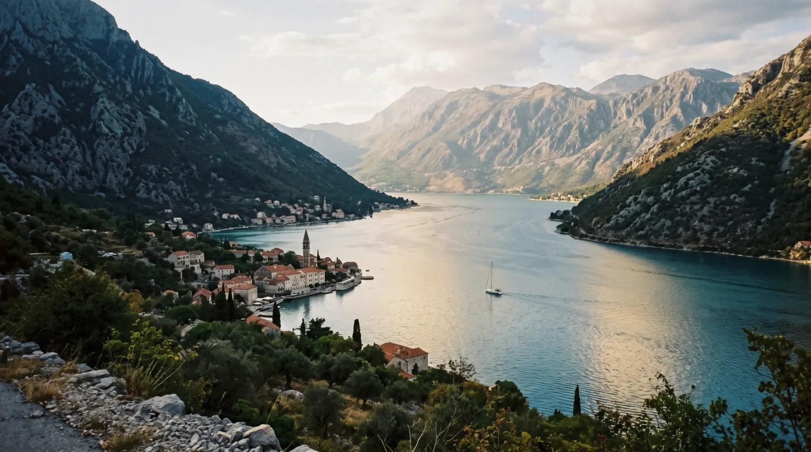
The Bay of Kotor: a Ria, Four Bays and the Strait the Ships Queue For
The Bay of Kotor is the reason Kotor exists. Montenegro's Adriatic coast runs flat and beachy until it reaches this one place, where two walls of Dinaric mountain drop straight into a branched channel of deep calm water that reaches 28 km inland. Locals call the whole thing Boka. It looks like a fjord, behaves like a lake and is technically neither. It is a ria, a drowned river valley, and that single geological fact explains everything you will see: why the water is so deep and still, why the towns cling to a shoreline of 107.3 km, why the mountains squeeze the road onto one narrow corniche, and why every cruise ship in the Adriatic has to line up and take turns at a strait only 340 m wide. This page is the geography: what the bay is, the four inner bays and their towns, the strait the ships queue for, and the cheapest and best ways to circle it. For what to do in town, hand over to things to do in Kotor. For the full tour market, see Kotor tours. The full guide lives on Kotor City Guide.
Quick answer The answer first, then the details that decide it
The Bay of Kotor (Boka Kotorska) is a drowned river valley about 28 km long, covering 87 square kilometres, up to 60 m deep with an average depth of 27.3 m. Four inner bays, Tivat, Herceg Novi, Risan and Kotor, are joined by narrower channels and open to the Adriatic past Prevlaka on the Croatian side. Walking its shores is free. To see it properly from the water, the best-value option is the Boka Bay full-day guided cruise at US$29 for eight hours, which runs the whole loop past Perast, the strait and Herceg Novi. If you would rather see Montenegro by road and river instead, the Montenegro highlights day trip at US$113 swaps the bay loop for the lake cruise at Rijeka Crnojevića. Decide one thing before you plan anything else: do you circle the bay by boat, or by road? The boat wins on views per euro. The road wins if the sea is rough or you want the mountain villages.
Key takeaways
- lists at $29.00, with free cancellation up to 24 hours before. Details on Boka Bay full-day guided cruise with swim stop.
- lists at $113.00, with free cancellation up to 24 hours before. Details on Montenegro highlights day trip with lake cruise.
- The next stop after this page: Perast and Our Lady of the Rocks.
Key facts
Opening hours
| The bay itself | always open–boat tours run in daylight |
|---|
Closed none, the water never closes
Admission
- Adult
- free to visit, boats extra
- Reduced
- not stated
- Free
- the shoreline, the views and the towns cost nothing to walk
Planning it
- Time needed
- a half day by boat circuit, a full day for the whole bay
- Book ahead
- Recommended — a few days
- Address
- Bay of Kotor (Boka Kotorska), Montenegro
- GPS
- 42.48, 18.72
Ways to See the Bay and What They Cost Tour prices are as listed on the booking platform and checked by this guide against the operators' own pages.
Do you circle the bay by boat, or by road?
| Option | Price | What you get | Cancel | Book |
|---|---|---|---|---|
| Everyone. The shoreline promenade, the viewpoints and all six bay towns cost nothing to walk. You pay only for boats, museums and island entries. | Everyone. The shoreline promenade, the viewpoints and all six bay towns cost nothing to walk. You pay only for boats, museums and island entries. | not stated | Official site | |
| The whole bay in one day on a covered ship, with a swim stop and a Blue Cave pass when the sea allows. The cheapest per-hour way to see the full length of the ria. Booking via the platform bills in your own currency. | The whole bay in one day on a covered ship, with a swim stop and a Blue Cave pass when the sea allows. The cheapest per-hour way to see the full length of the ria. Booking via the platform bills in your own currency. | Free to cancel up to 24 hours before | Check Availability | |
| For travellers who have already seen the water and want the country behind it: the Lovćen back road, Cetinje and the Rijeka Crnojevića boat ride in a small group, back before dinner. | For travellers who have already seen the water and want the country behind it: the Lovćen back road, Cetinje and the Rijeka Crnojevića boat ride in a small group, back before dinner. | Free to cancel up to 24 hours before | Check Availability |
Tour prices are as listed on the booking platform and checked by this guide against the operators' own pages. Figures current in Q3 2026.
Bay and Boat Tours
Two booked circuits earn their place on a geography page, because each one teaches you the bay in a different way. The first follows the water the whole way round. The second leaves it and shows you why the water is here at all. Both are listed on the platform in your own billing currency. The full loop. Perast, the Verige Strait, Herceg Novi and the Blue Cave weather permitting, on a big covered ship with a guide and a swim stop. Rated 4.3 from 1,216 reviews. The land-and-river alternative. Eight hours, small group, and the Rijeka Crnojevića boat ride the bus tours skip. Rated 4.7 from 280 reviews.
Start with the word. A fjord.
Start with the word. A fjord is carved by a glacier. A ria is a river valley that the sea climbed into when sea levels rose, and the Bay of Kotor is the drowned mouth of a river called the Bokelj, which no longer exists as a surface river. That is why the bay does not look like the open Adriatic coast at all. It branches. Four inner bays, Tivat, Herceg Novi, Risan and Kotor, sit like rooms off a corridor, joined by narrower channels, and the whole system opens to the sea past the Prevlaka peninsula on the Croatian side. The numbers tell the story better than the adjectives. About 28 km long, 87 square kilometres of surface, up to 60 m deep with an average of 27.3 m, and 107.3 km of shoreline wrapped around all that water. Compare that shoreline with the map area and you get the bay's defining feature: an enormous amount of coast in a very small box, which is exactly why so many small towns could grow here, each on its own pocket of shore.
The practical consequence for your trip is that the bay has almost no tide or swell in its inner reaches. The water is calm, deep and clear. It is why the big day cruises run so reliably, why sea kayaking the bay is a real option rather than a stunt, and why Kotor town itself swims off stone slabs and quays rather than sand. There is no sandy beach in Kotor town, a point we treat at length on the beaches page. The sand people search for sits across the water on the Tivat side and down the coast toward Budva.
The second consequence is orientation. With mountains on both sides, the road has no choice but to follow the shore, so the bay reads like a sequence rather than a maze. Drive or sail the loop and the towns arrive in order. That makes Boka one of the easiest landscapes in the Adriatic to understand from a single day of movement, and it is why our Kotor map page draws the bay as a line with stops rather than a grid.
The Towns of the Bay, One by One
Six towns ring the water, all well preserved, each with its own character and its own page on this guide where one exists. Work through them in the order you will meet them on the loop and you have the bay's whole human story in an afternoon. Kotor is the anchor, the town at the dead end of the deepest inlet, walled and towered and sitting under its fortress. Venice ruled it from 1420 to 1797 and the architecture shows it. The old town has been on the UNESCO World Heritage list since 1979, the year an earthquake damaged it. The town holds maybe 1,360 residents inside the walls and is the reason most visitors come at all. Our full coverage is at Kotor old town, the fortress, St Tryphon's Cathedral and the Maritime Museum. Perast, 12 km up the coast road from Kotor, was the bay's seafaring aristocracy in miniature, a town of captains' palaces at the point where the inner bays meet. Its baroque parish church of St Nicholas carries a bell tower, the tallest on the bay. Perast's other half sits offshore: Our Lady of the Rocks, an artificial island built over centuries from rocks and scuttled stone-loaded ships, where seamen laid a rock on each successful voyage. Water taxis from the quay run about €5 ($5.71) return and the church-museum charges €3-5 in cash. Details at our Perast page. Risan is the quietest of the six and the oldest. It sits at the head of the innermost inlet, the point where the drowned Bokelj river would have entered the sea, and its mosaics testify to a Roman settlement that predates everything Venetian around it. This page states the fact of its place among the bay's well-preserved towns, sourced to the standard reference summary of the bay, and leaves the visiting details to a slower itinerary. Prčanj lies on the Kotor side of the loop, a former captain's village of stone palaces along one long waterfront street, on the road you will drive or bus between Kotor and Tivat. It never developed into a tourist stop, which is precisely its appeal on a crowded bay day. Tivat is the modern outlier, flat where the rest of the bay is vertical, built around what was a naval arsenal and now home to a large marina development. It is also the practical side of the bay for flights, since Tivat airport sits about 5 km from Kotor, and the boarding point for cruise departures of the full-day bay cruise, which some travellers find easier by car. Herceg Novi guards the bay's mouth on the eastern entrance, a town of fortresses and stairs at the point where Boka meets the open Adriatic. It belongs more to the bay's entrance story than to the inner loop, and it is the closest bay town to the Blue Cave, which sits on its side of the entrance. The table below puts the six in loop order with the practical line for each.
The Six Towns at a Glance
Distances along the coast road and the practical hook for each stop, so you can decide which two or three earn a stop on your day.
| Town | Position on the bay | Why stop | Guided coverage |
|---|---|---|---|
| Kotor | Head of the innermost bay | Walled UNESCO town, fortress, cathedral, the cruise pier | Own guide pages, plus the old town walking tour listed on its page |
| Prčanj | Kotor side, between Kotor and Tivat | One waterfront street of captain's stone houses, no crowds | Not covered by a dedicated page on this guide |
| Tivat | The flat bay, arsenal and airport side | Marina, airport access, cruise boarding for the big bay ship | See getting around Kotor for the crossing |
| Perast | Where the inner bays meet | Baroque palaces, tallest bell tower, Our Lady of the Rocks offshore | Full page at /perast/ |
| Risan | Head of the innermost inlet | Oldest settlement, Roman mosaics, quietest shore | Not covered by a dedicated page on this guide |
| Herceg Novi | The bay's mouth | Fortresses, stairs, gateway to the Blue Cave | Approached via /blue-cave-kotor/ |
Two-thirds of the way from Kotor.
Two-thirds of the way from Kotor to the open sea, the bay pinches. The Verige Strait runs 2,300 m end to end and is only 340 m wide at its narrowest point. Limestone slopes drop on both sides, the water deepens, and every vessel entering or leaving the inner bays must pass through this one gap. That includes the cruise ships. A ship bound for the pier in Kotor has no alternative route, so when two or three calls stack up on the same morning the ships line up and take turns at the strait, and arrival times slip down the day. The Port of Kotor calls itself the third cruise destination in the Adriatic after Venice and Dubrovnik, with about 523 calls from roughly 85 ships scheduled for 2026, about 41 of them in September alone. Multiply that by the strait's width and you understand the queuing.
For the visitor the strait works in your favour twice. First, it is the scenic climax of every boat trip, the moment the channel narrows and the mountains close in, and the big ships provide an unexpected sense of scale as you pass them. Second, the queue is predictable. On heavy cruise days the old town fills within minutes of the first gangway dropping, since the pier sits about 100 m from the walls and passengers walk 2-5 minutes to the Sea Gate. Check the cruise port page for how the schedule shapes each day, plan the fortress climb or the water for those hours, and read best views of Kotor for where to watch the ships thread the gap from above. In 2019 Kotor welcomed over 250,000 tourists in the year and the growth has continued since the early 2000s cruise boom, which is why the strait has become the bay's most consequential 340 m.
The bay is walled in by.
The bay is walled in by two Dinaric massifs, and they are not scenery, they are machinery. To the west rises Orjen, whose summit Veliki kabao reaches 1,894 m and records about 6,250 mm of precipitation a year, among the wettest stations in Europe. To the east stands Lovćen, greener, gentler on its seaward face, and crossed by the serpentine road and now the cable car. Between them they catch the moist Adriatic air and wring it out, which is why the bay's winter rain figures dwarf its summer ones and why the mountains, not the sea, make the bay's weather. November averages 354 mm of rain at Kotor against 62 mm in July, a spread the massifs are entirely responsible for.
This has direct consequences for your plans. The bay's rain arrives in autumn and winter storms that can close the cable car for wind with little notice, so check Kotor weather if you are travelling in the shoulder months. In the other direction, the mountains are the bay's escape valve on hot days, since Kotor's average July high is 29.6 °C while the ridge above sits a climate zone cooler. Both massifs reward the climb: Lovćen national park with the Njegoš mausoleum on its summit and Njeguši village on the old road, and Orjen as the wilder, wetter, less-developed wall, best appreciated from the water or from the ridge road. If you would rather hand the driving to someone else, the Lovćen cable car, Njeguši and Cetinje day tour covers the eastern massif's three stories in seven and a half hours.
The bay's timeline explains its towns.
The bay's timeline explains its towns. Each era left its layer, and because the shoreline is narrow and continuous, you can walk the sequence in a single day.
The Illyrians held these shores before written records in the region, living off the sheltered water and the mountain slopes. Risan, at the head of the innermost inlet, carries the bay's oldest continuous settlement story. The Roman period followed, with Risan as a documented Roman town whose mosaics still survive, evidence that the sheltered ria was prized as a harbour two thousand years ago.
The year 535 brings the first fortification above Kotor, when Justinian's fort stood on the hill where San Giovanni fortress now crowns the walls. The walls were extended through the Serbian and Venetian centuries that followed, and a fortress has watched the innermost bay ever since.
Venice took Kotor in 1420 and held it until 1797. Those 377 years wrote the bay's character: the stone palaces of Perast's captains, the Venetian gates and campaniles of Kotor, the Catholic-Orthodox double life of churches like St Luke's. Venice organised the bay's shipping, its defence and its aristocracy, and the bay's very name in everyday use, Boka, outlived the republic that shaped it.
Earthquakes are the bay's recurring catastrophe. The 1667 quake wrecked Dubrovnik and badly damaged St Tryphon's Cathedral, and the April 1979 earthquake damaged Kotor badly enough that the town's UNESCO inscription, made that same year, was in part an act of rescue. The Natural and Culturo-Historical Region of Kotor has been on the World Heritage list since 1979, and the fortifications joined UNESCO's Venetian Works of Defence listing in 2017.
The cruise era is the newest layer. Growth since the early 2000s turned the pier at Kotor into the Adriatic's third cruise call, over 250,000 tourists in 2019, about 523 ships' calls scheduled for 2026, and a queue of vessels at the Verige Strait on every busy morning. The bay that once sheltered river sailors and Venetian galleys now takes turns at a 340 m gap.
A geography page deserves a practical.
A geography page deserves a practical footer. These are the rules of thumb we would give a friend planning a first loop of Boka.
Do pick your boat day by the cruise schedule, not the weather alone. The bay is calm most mornings, but the old town doubles in population on heavy ship days, and the water is where you want to be then.
Do ride at least one circuit that passes the Verige Strait. It is the bay's defining pinch and the photograph that explains the geography better than any map. The full-day cruise threads it as part of the loop.
Do carry cash. The Our Lady of the Rocks island admission is €5 ($5.71) per guest, cash only, since April 1, 2026, and the church-museum at Perast charges €3-5 in cash. Montenegro uses the euro unilaterally, though it is not in the eurozone.
Do not swim from the rocks in swimwear-adjacent situations at the island. A dress code applies there, swimwear not allowed. Swim from the boat instead, which is what the circuits build in.
Do not assume the beach. Kotor town has no sandy beach, swimming is off stone slabs and quays, and no lifeguards are mentioned by any official source for the Kotor-side spots. The sand is on the Tivat side and toward Budva, covered on the beaches page and in Kotor with kids for families.
Do not try to drive the whole loop at the evening peak in summer. The shoreline road is the only road, and it is shared by buses, ferries at the Kamenari-Lepetane crossing and every rental car on the coast. Our getting around Kotor page sorts the options.
Do budget for the small taxes. The residence tax is €1.00 ($1.14) per person per night, under 12 exempt, and your accommodation registers you. The rest of the ledger lives on Kotor costs.
The facts that change how the.
The facts that change how the bay looks once you have them.
The bay is the mouth of a river that has vanished. The ria was carved by the Bokelj River, which no longer flows on the surface. Stand at Risan, the head of the innermost inlet, and you are standing where a river used to reach the sea.
It is shallower than it looks. The bay reads as bottomless, but it reaches at most 60 m deep, with an average of 27.3 m. That is a deep lake, not an ocean trench, and it is part of why the water is so calm and clear.
The shoreline is absurdly long for the area. 107.3 km of coast wrap around 87 square kilometres of water. All those coves, quays and small towns exist because the ria folds the coast back on itself again and again.
One European record sits above the water. Orjen's Veliki kabao, 1,894 m, takes about 6,250 mm of precipitation a year, one of the wettest stations on the continent. When it rains on the bay all day, blame the mountain, not the sea.
The strait is narrower than a container terminal. The Verige Strait is 2,300 m long and 340 m wide at its tightest, and ships of hundreds of passengers thread it in both directions. Watch one pass from the Perast side and the number stops being abstract.
A sixth, for free: the bay costs nothing. Unlike the fortress walls at €15 ($17.12) or the cable car at €25 ($28.53) return, the water and every metre of shoreline promenade are free, and free things to do in Kotor starts with the bay itself.
Nearby on This Guide
Perast and Our Lady of the Rocks
The bay's most photogenic pair, 12 km from Kotor by the coast road. The artificial island of Our Lady of the Rocks was built over centuries from stones and scuttled ships, and every 22 July at sunset the fašinada procession rows out to throw more stones and widen it, an unbroken custom. Water taxis run about €5 ($5.71) return from the quay. Our Perast page and Our Lady of the Rocks page carry the full practical detail.
The Blue Cave
On the Herceg Novi side of the bay's entrance, reachable only by boat, with about 20-25 minutes each way by speedboat from Kotor. The rule changed in the 2026 season: boats no longer enter the cave, and you swim in from the mouth when the skipper judges the swell safe. The cave charges no entry fee of its own, the cost is the boat. Read the Blue Cave page before booking, and the speedboat tour that covers the classic circuit.
Lovćen National Park
The eastern wall of the bay and the fastest escape from its summer heat. The serpentine road and the cable car both cross it, Njegoš mausoleum crowns it, and Njeguši village sits on the old road with its ham and cheese. Pair it with Cetinje, the old royal capital, on a mountain day. Start at Lovćen national park and Cetinje.
Bay of Kotor: Frequently Asked Questions
Is the Bay of Kotor a fjord?
No. It is often called Europe's southernmost fjord, but a fjord is carved by a glacier and this is a ria, a river valley drowned by rising seas. It is the vanished mouth of the Bokelj River. The look is the same, the origin is different, and the difference is why the bay branches into four inner bays instead of running as one channel. The geography is laid out on this page.
How deep is the Bay of Kotor?
Up to 60 m at its deepest, with an average depth of 27.3 m across 87 square kilometres. That is deep enough to feel oceanic and shallow enough to keep the water calm and clear in the inner reaches. The length is about 28 km and the shoreline runs 107.3 km.
What towns are on the Bay of Kotor?
Six well-preserved towns ring the water: Kotor, Risan, Perast, Prčanj, Tivat and Herceg Novi. Kotor is the walled anchor at the head of the innermost bay, Perast the baroque captains' town, Risan the oldest, Prčanj the quiet one, Tivat the flat modern bay and Herceg Novi the gate at the entrance. The towns are covered one by one in the guide section above and at our Perast page.
How long does a bay cruise take?
The full loop of the bay runs eight hours on the Boka Bay full-day guided cruise, which passes Perast, the Verige Strait, Herceg Novi and the Blue Cave when the sea allows. Shorter circuits exist: the speedboat trips to the Blue Cave area take about 20-25 minutes each way, with the whole three-to-four-hour route described on the Blue Cave page. The hop-off alternative by road is mapped on getting around Kotor.
Why do cruise ships love Kotor?
Because the approach is the attraction. Ships must thread the Verige Strait, only 340 m wide at its narrowest, with mountains on both sides, and dock about 100 m from the old town walls, so passengers walk 2-5 minutes to the Sea Gate. The Port of Kotor calls itself the third cruise destination in the Adriatic after Venice and Dubrovnik, with about 523 calls from roughly 85 ships scheduled for 2026. The mechanics of a call, and the crowd timing, are on the cruise port page.
Is the Bay of Kotor worth seeing from the water or the road?
Both, if you have two days. The water gives you the strait, the scale of the mountains and the towns from the angle they were built to be seen from, and the cheapest full circuit is the full-day cruise at US$29. The road gives you the serpentine, Njeguši and the view down from above, covered in Lovćen national park and our Kotor itinerary pages. If you must choose one and the sea is calm, choose the boat.
Bay of Kotor on Film
Three videos that show the place before you go. They load from YouTube only when you press play.
Bay of Kotor, Montenegro 🇲🇪 in 4K Ultra HD | Drone Video
A walk or ride through the subject of this page.
Video: Explore The World 4K4K Aerial and Ground View of Kotor, Montenegro
A walk or ride through the subject of this page.
Video: Slavica StajićMontenegro in 4K UHD Drone
A walk or ride through the subject of this page.
Video: Go Places ProVideos load from YouTube only when you press play.
Prices, hours and terms are set by the venue or operator and confirmed at checkout.
We may earn a commission if you book through one of our links, at no extra cost to you. Full affiliate disclosure